
South Australia’s pioneering satellite, Kanyini, has delivered its first images from space, marking a significant milestone for the mission.
Deployed on SpaceX’s Transporter-11 mission last August, Kanyini has spent 194 days in low Earth orbit, closely monitored by the mission control team at Inovor Technologies, based at Adelaide’s Lot Fourteen innovation district.
Since it was launched, the team has been working through the commissioning of the satellite’s systems, confirming that the solar panels and batteries are functional and X-band radio communications are all operational.
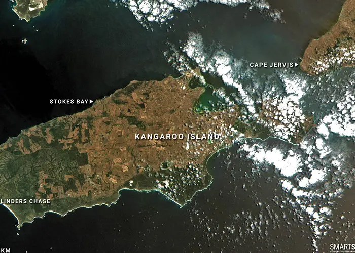
Several preliminary images have been collected during Kanyini’s on-orbit commissioning phase, demonstrating the incredible depth of data the satellite can provide once fully operational.
The first processed images, now released, capture high-resolution views of South Australian regions, including Kangaroo Island, Yorke Peninsula and Adelaide.
The vast amount of data behind each image allows them to be processed to reveal infrared details normally invisible to the human eye. The data can be used in monitoring crop health, vegetation density and changes in inland and coastal water conditions.
The HyperScout 2 hyperspectral imager capturing the views is a three-in-one instrument that combines hyperspectral and thermal imaging with high-level data processing and artificial intelligence capabilities.

The satellite also features an Internet of Things (IoT) payload developed and manufactured in South Australia by Myriota, enabling Kanyini to capture both imagery and IoT data, such as groundwater levels and pipeline condition, from a single satellite.
The Kanyini mission is Australia’s first state-owned satellite and is a joint initiative between the South Australian Government, SmartSat CRC, Inovor Technologies and Myriota.
As of February 28, Kanyini had completed 2,788 revolutions of Earth at an average speed of 27,386 kilometres per hour. Orbiting Earth at 516 kilometres above sea level, it has flown 9,034,937 kilometres to date.
Over the coming months, the mission team will continue to progress the commissioning and calibration process of the satellite’s systems, ensuring its functions and data output meet the highest scientific standards.
Once fully operational, Kanyini will deliver critical space data to support future research projects by government and research institutions, particularly in the areas of sustainability and climate impacts.


