HEO and BAE Systems have announced a collaboration on an advanced geospatial exploitation solution to provide customers with an integrated view of the space domain.
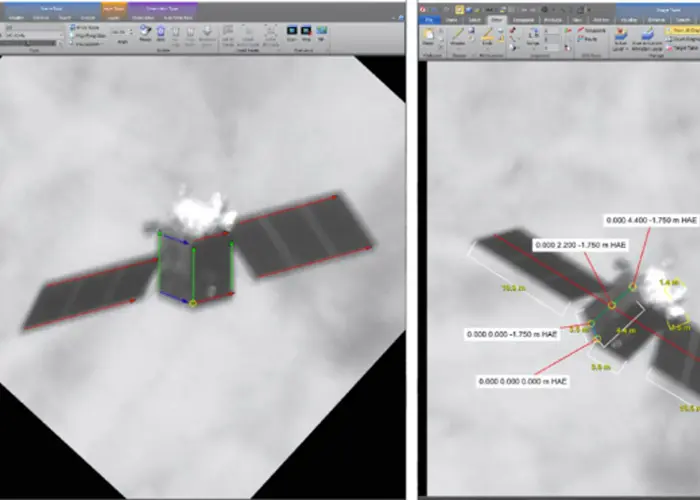
The customised product combines HEO’s resolved non-Earth imagery with BAE Systems’ newest SOCET GXP software capability, non-Earth registration, which enables sensor model creation, mensuration, and analysis.
This innovation allows customers to create sensor models for HEO’s non-Earth imagery data intuitively and immediately derive insights utilising SOCET GXP’s proven exploitation capabilities and workflows.
This collaboration meets the growing demand for high-quality, actionable, and accurate resolved non-Earth imagery insights in support of national security, civil, and commercial space operations.
Space operators can directly import HEO’s non-Earth imagery data into SOCET GXP software and make full use of its exploitation and dissemination tools to derive insights on the health, status, and operation of their space vehicles.
“Making our data as accessible and usable as possible is a top priority for us,” said HEO CTO Hiranya Jayakody. Our collaboration with BAE Systems offers our customers the flexibility to access our data through their tool of choice.”
“Previously, our customers accessed our non-Earth imagery data and products through our HEO Inspect 3.0 web-app. With this integration, customers using the SOCET GXP software solution can leverage a world-class suite of data exploitation tools without disrupting current analytic workflows.”
BAE Systems’ GXP software enables rapid discovery, exploitation, and dissemination of mission-critical geospatial data. SOCET GXP users will now have more access to a comprehensive, integrated view of the space domain derived from in-orbit observations, allowing for more informed decision-making and faster response times for various defence and intelligence applications, providing a clear strategic advantage.
“With the introduction of Non-Earth Registration into SOCET GXP and HEO’s high-quality non-Earth imagery, we are extending our industry-leading geospatial exploitation capabilities into the space domain,” said Kurt DeVenecia, senior director of GXP product development at BAE Systems.
“It empowers analysts to perform precise measurements, analysis, and modelling on NEI with the same level of confidence they expect from terrestrial data,” he added. “This capability is a critical enabler for space domain awareness, ensuring that our customers have the advanced tools they need to model, monitor, and protect assets in the increasingly dynamic space environment.”


