Europe’s next-generation weather satellite has returned its first images, offering an early glimpse of how the mission will transform weather forecasting across Europe and northern Africa.
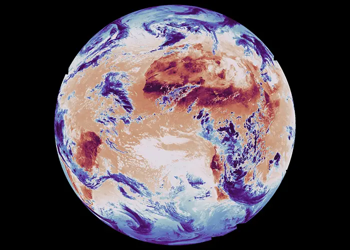
The first two images from the Meteosat Third Generation-Sounder (MTG-S) satellite were unveiled at the European Space Conference in Brussels. Captured on 15 December 2025 by the satellite’s Infrared Sounder instrument, the images show a full-disk view of Earth from geostationary orbit, approximately 36,000 kilometres above the planet.
One image highlights temperature distribution using a long-wave infrared channel, measuring both Earth’s surface temperature and the temperature at the tops of clouds. Warmer regions appear in dark red, while cooler areas, typically cloud tops, are shown in blue. The image clearly shows the warm landmasses of Africa and South America, with the west African coastline and the Cape Verde peninsula among the hottest regions. Cooler cloud systems are visible swirling over parts of southern Africa and the South Atlantic.
The second image focuses on atmospheric humidity, captured using a medium-wave infrared channel. In this view, blue tones indicate higher humidity, while red areas show drier air. Large regions of low humidity are visible over the Sahara Desert and the Middle East, while a broad dry zone is also evident over parts of the South Atlantic Ocean. Patches of high humidity appear across eastern Africa and at various latitudes.
MTG is a flagship Earth observation mission developed by the European Space Agency with European partners to address major scientific and societal challenges. The mission is designed to deliver game-changing data for weather and air-quality forecasting over Europe.
Positioned in geostationary orbit above the equator, MTG-S maintains a constant view of the same region of Earth as the planet rotates. This allows the satellite to provide continuous coverage of Europe and parts of northern Africa, with temperature and humidity data updated every 30 minutes. Combined with cloud and lightning observations from the MTG-Imager satellite, meteorologists will gain a far more complete and timely picture of evolving weather systems.
ESA’s Director of Earth Observation Programmes, Simonetta Cheli, said the first Infrared Sounder images bring the mission’s potential to life, noting that the data is expected to significantly improve the forecasting of severe storms across Europe and deliver more accurate and timely warnings for communities.
The Infrared Sounder on MTG-S is the first European hyperspectral sounding instrument placed in geostationary orbit. Using interferometric techniques to analyse fine patterns in light waves, it captures detailed data on temperature and humidity, and can also measure winds and trace gases. Ultimately, the instrument will enable the creation of three-dimensional maps of the atmosphere, improving short-term “nowcasting” of rapidly developing storms.
ESA’s MTG Project Manager James Champion said the satellite represents the culmination of 15 years of development and will revolutionise weather forecasting in Europe, particularly through its ability to repeatedly profile the atmosphere with high temporal resolution.
ESA officials say the full capability of the Infrared Sounder, which continuously acquires data across around 1,700 infrared channels, will soon provide an unprecedented view of Earth’s atmosphere, helping forecasters predict extreme weather events earlier than ever before.
Image: Global surface and cloud-top temperatures by MTG-Sounder – credit: ESA


