
ST Engineering has outlined the next phase of its space programme at the Space Summit held during the Singapore Airshow 2026, announcing plans to design and develop new satellites in Singapore over the coming years, alongside new geospatial solutions integrated with advanced digital technologies.
The company said the programme will contribute to the continued development of Singapore’s space industry, with a focus on locally developed satellite platforms and data-driven applications for civil and commercial use.
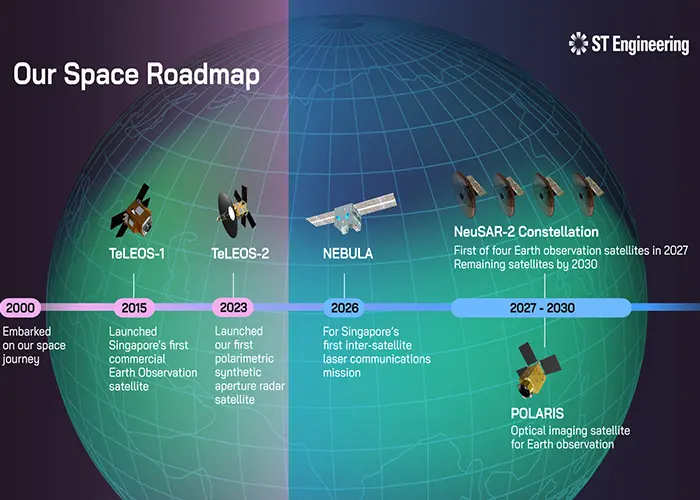
As part of the roadmap, ST Engineering is preparing to deliver NEBULA, Singapore’s first pathfinder demonstrator for advanced inter-satellite laser communications, in the second half of 2026. The satellite is intended to validate gigabit-per-second data transfer capabilities, which the company said will underpin future ultra-fast space networks supporting global broadband connectivity, Earth observation and secure data exchange.
ST Engineering also confirmed plans to deploy four new Synthetic Aperture Radar satellites under the NeuSAR-2 Constellation by 2030. The first satellite is scheduled to be launched in 2027. Operating in near-equatorial low Earth orbit, the fully deployed constellation is expected to provide high-revisit, high-resolution imaging across equatorial regions, supporting applications including environmental monitoring and disaster response planning.
In addition, the company will begin research and development on POLARIS, a new optical imaging satellite designed for near real-time Earth observation. POLARIS is expected to incorporate next-generation capabilities such as onboard artificial intelligence processing to enable faster data analysis in orbit.
“Our space programme is founded on proven engineering excellence and technical innovation,” said Low Jin Phang, Chief Operating Officer for Defence & Public Security and President for Digital Systems at ST Engineering. “This allows us to develop more advanced SAR and optical imaging satellites in Singapore for a wide range of missions, while applying artificial intelligence to satellite systems and geospatial solutions to address real-world challenges for customers globally.”
ST Engineering said the initiatives announced at the Space Summit reinforce its long-term commitment to building indigenous satellite capabilities in Singapore while expanding the use of space-based data for commercial and public-sector applications.


